Blanca Group - Alamosa Trip
- Sangre de Cristo Range
Summary
Mount Lindsey Elevation 14,047ft. (Aug. 30, 2003) "North Face", trail from Huerfano River TH, this class 2+ trail runs (7.8 miles rt. with 3,400ft. gain). Blanca Peak, Ellingwood Point Elevation Blanca 14,349ft. Ellingwood 14,049ft.(Aug. 31, 2003) "Northwest Face of Blanca and South Face of Ellingwood", trail from Como Lake TH, this class 2 trail runs (4.5 miles rt. with 3,000ft. gain). Little Bear Peak Elevation 14,040ft. (Sept. 1, 2003) "West Ridge", trail from Como Lake TH, this class 4 trail runs (2.2 miles rt. with 2,150ft. gain). The climb on Lindsey was done with out much visibility, the climb on Blanca and Ellingwood were done on ice covered rocks, and the climb on Little Bear was done with perfect weather and only four other hikers on the entire route.
Read More Details or View Slideshow
Trip Schedule break down
| Friday | 12:01PM | -left work (drove to Walsenburg and then to Red Wing) |
| 3:30PM | -arrive at Huerfano River 4X4 Trail Head. | |
| Saturday | 6:18AM | -leave the TH to climb Mount Lindsey. |
| 8:55AM | -summit Lindsey via North Face. | |
| 10:58PM | -back at TH.. | |
| 2:00PM | -arrive a Lake Como road (1.6miles up) | |
| 3:40PM | -leave truck to backpack into Lake Como. | |
| 6:10PM | -arrive at Lake Como and setup camp. | |
| Sunday | 6:10AM | -leave campsite. |
| 8:35AM | -summit Blanca Peak via Northwest Face. | |
| 9:45AM | -summit Ellingwood Point via South Face. | |
| 11:50AM | -back at campsite. | |
| Monday | 5:45AM | -leave campsite. |
| 7:40AM | -summit Little Bear Peak via West Ridge. | |
| 9:35AM | -back at campsite. | |
| 11:00AM | -pack up campsite and head for the truck. | |
| 12:23PM | -back at the truck. | |
| 4:45PM | -back at home. |
Saturday
The weekend began by deciding at the last minute
to do the climbs in totally reverse order of what had been planned the entire
previous week. This decision was made because I was going to be minus my
climbing partner for the weekend, and the weather looked like it was going to be
the worst on Saturday and then improve over the rest of the weekend. By doing
the climbs in reverse order I hoped to do the easiest climb first with the worst
weather and do the hardest climb when the best weather was predicted. I have to
say that as far as planning around the weather, I ended up dead on
this weekend.
The road up to the Huerfano River TH is a little difficult, but a high clearance 2 wheel drive vehicle could probably make it. I think that cars could probably make the trip as well; there was a section of road that looked like a car took to the grass instead of the road. The road had a couple good sized rocks in it....therefore the grass was a little easier for a car to go up. At the trailhead there is minimal parking but I had beat the traffic. In the morning I found a number of other vehicles in the parking lot and even a couple hikers that had already left for the summit before me.
The trail starts off straight forward. and the Roach book is pretty good, the crux of the trail is to find the trail that leaves the creek trail next to the swamp/lake and follows the South side of a large talus field. The trail is a little tricky to find in the dense vegetation and marshy ground, but if you find the talus field you are on your way to the summit. The rest of the trail goes up a grassy ravine and then up a slope on the right hand side of a valley before dropping into the valley and continuing to your left over to the grassy "ramp". I had good visibility over to the "ramp," but then the rest of the climb was in the clouds. The trail continues up and then traverses through a talus field over to the saddle between the "Iron Nipple" and Lindsey. Once on the ridgeline you continue up and then around the left side (North Face) and up a rock couloir, this starts the class 2+ climb. You actually traverse around the lift side for some time, so don't head up a couloir too soon. Once you are up the first couloir you have to traverse over loose rock and sand to another couloir. Once you are up the final couloir the summit is about a 1/5th of a mile down the ridgeline to your left or Southeast.
Because this entire last section was in the clouds I could only hope that I was climbing the right peak, the valley where the ramp is, contains a number of other trails so I was happy to see some other climbers ahead of me. I guess the real story is that I was glad to hear some climbers ahead of me on their way down say that they had reached the summit. It was fortuitous that I met this climbing couple at the transition between the two couloirs and neither of us were in a single couloir at the same time. I could definitely see where people have slid off of Lindsay to their death. I knew of one person though me friend Nick, who had done just that.
Sunday
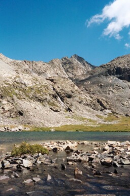
This day started off after and 3+ hour backpack in to Como
Lake the previous afternoon in a rain storm. My truck made it about 1.5 miles up the Como road
before I decided to just walk in. By showing up on the Como road late Saturday
afternoon I was witness to the droves of vehicles that had made it to various distances
up the road at the beginning of this Labor Day weekend. The most amazing sight was how
far a Suzuki Sidekick made it up the road, I guess with its short frame and wheelbase
it could just about drive around any obstacle. The road is quite notorious for vehicle
carnage, so if you need more information check out a 4X4 trail website.
Sunday morning, I woke up to clear skies, but that was soon to change. The hike up to the endless rock pile was easy, but once on the rocks, the trail became very difficult where foot placement and weighting was key. During the rain storm the previous day, it was actually snowing up above the 12,500 foot mark. So once on the rock pile up Blanca, I encounter a thin layer of ice covering the surface of all the rocks. Adding insult to injury the clouds moved it at this point and obstructed my view of Blanca's summit. There are many cairned routes up Blanca and I think the best possible route is to stay in the middle of the large talus face on Blanca and then traverse to Blanca Northwest ridge before gaining the summit. There were numerous hikers turning around at this point, but I felt determined and I was prepared having brought my winter gear for this weekend. Some hikers were not so well prepared, a hooded sweatshirt with no hat or gloves doesn't cut it.
After summiting and making the careful and slow descent off of Blanca I made it down to a clearing were I knew I had seen a good cairn path to Ellingwood. I presume that there is a higher traverse that stays above the year-around snow field, however in zero visibility I was not going to take a chance. Once at the base of the snowfield the clouds ended up drifting in and out making it a little easier to see. The climb up Ellingwood goes up the West side of the snow field rather steeply, onto some rock ledges and then a long traverse all the way to the summit. By the time I came off of Ellingwood the visibility had improved greatly and the rest of the day was perfect.
Monday
This day was the crux of the entire
trip, Little Bear was the last of my class 4 climbs. Little Bear is grouped among
the most feared of 14ers, mainly because of traffic issues that make climbing
dangerous. The rock chutes on the a climb of Little Bear lend themselves to the occurrence
of rock debris pin-balling its way down the slope on to climbers below. This
morning I passed some other hikers right at the lake and then stayed ahead of
them all the way to the summit. The first part of the climb takes you up a loose
sand and large boulder couloir to the West ridge of Little Bear. Once up the couloir
the trail stays off the ridgeline on the backside and traverse all the way to
the second notch/alternate couloir on Blanca. The trail continues to traverse
over and underneath the ("bowling alley", "hour glass",
"rock chute"... pick one). At this point I found a rope left hanging in the
middle of the gully where water was running. The hardest part of the climb is
the 20ft. right at the solid rock surface. The combination of water and
sand on this solid rock surface makes for a difficult 20 ft. of climbing. After
you get up past this section, in one fashion or another, the main trail stays to
the left, over to a ridgeline, and then up to the right along the ridgeline to
the summit. The trail only
takes one slight deviation from the ridge near the top, where it does an
traverse over the main gully and then back to the summit.
The views off of Little Bear were absolutely incredible, my pictures could not even get close to the view I was experiencing. I was above the clouds looking out over a sea of white fluff where only the tops of the Sand Dunes and Crestone group could be seen basking in the early morning sun. I was lucky to find that the two climbers behind me were on their way across the ridgeline to Blanca and on their way to doing the whole triad in one day, so that I could proceed back down the gully without worrying about them knocking roak down on me during their decent. The way down went better then up, surprisingly enough, however the last 20ft.out of the "hour glass" was still equally as difficult from the top side. The only other climbers I passed this day, were a couple who had just come up the couloir which gives you access to Little Bear's West ridge.
I made it back to camp, packed up, and headed for the truck before an afternoon storm could make the hike back down Como road any worse.