Handies Group - Lake City Trip
- San Juan Range
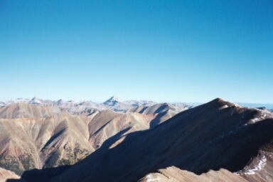
Uncompahgre and Wetterhorn in the background)
Summary
Redcloud, Sunshine, and Handies PeaksElevation Redcloud14,037ft. , Sunshine 14,006ft. , and Handies 14,053ft. (Sept. 21, 2002) Redcloud and Sunshine were climbed from the, "Silver Creek TH: Redcloud's Northeast and South Ridges finishing with Sunshine's North Slopes," this trail is a class 1 and 2, that runs (9.8 miles rt. with 4,700ft. gain). Handies was climbed from the, "American Basin TH: West Slopes," this trail is a class 1 and 2, that runs (5.6 miles rt. with 2,750ft. gain). The weather this weekend was prefect for climbing, with the ability to summit peaks safely into the afternoon hours. The only weather related issue I ran into was a staggering wind chill factor on top on Redcloud, however what do expect for a fall climb.
Read More Details or View Slideshow
Trip Schedule break down
| Friday | 12:00PM | -leave work (US-285 to Salida, West to Gunnison, and South to Lake City) |
| 5:30PM | -arrive at Silver Creek TH. | |
| Saturday | 5:30AM | -leave Silver Creek TH |
| 7:45AM | -summit Redcloud Peak (60 mph winds) | |
| 8:45AM | -summit Sunshine Peak | |
| 11:00AM | -back at Silver Creek TH. | |
| 12:00PM | -drive to and leave American Basin TH. | |
| 1:45PM | -summit Handies Peak. | |
| 3:18PM | -back a American Basin TH. | |
| 5:45PM | -drive over Cinnamon and Engineer Passes to Matterhorn TH. |
Expanding on my Handies Group outing, when I arrived at the Silver Creek TH there were two other cars. Of the two car there were three people and two climbers. On of these climbers, Joe, left the TH in the morning before me, but I caught me close to the summit of Redcloud. Joe then caught me on top of Sunshine just as I was leaving. I climbed the normal route for the combination of both peaks, however I descended into the valley bellow sunshine and headed back to the the TH. Dropping into the valley was very difficult with the loose rock and steep grade, I guess that is why it is usually only recommended for an early Spring descend when snow is still holding the slope from sliding. The only really interesting about this pair of peaks was the reddish and very porous rock. The rock almost seemed volcanic in nature.
After hurrying back to the Silver Creek TH and packing up, I drove up the road towards Cinnamon Pass to the American Basin TH to climb Handies. By this time it was noon, and the weather looked as clear as ever. The road that connects all the Trail Heads during this outing are part of the Colorado Scenic Byway, and with the changing of the fall colors the road drew a lot of traffic the weekend.
From the American Basin TH the path runs up a jeep trail, pass a very pleasant waterfall, and into American Basin. The trail looks to have been re-routed in the last year and the new trail heads further to the right and near to a high mountain lake. Following the new trail you end up adding an addition half mile to your trip however the trial is so well maintained and easy that you can not really care about taking those few extra steps. The easy trail makes the return trip back the trail head very nice.
The drive over Cinnamon Pass and Engineer Pass was very fun. Both Passes had numerous tight switchbacks which required me to back up and to take a more direct path (I drive a full size extended cab pickup). Engineer Pass had about a foot of snow but I did not have any problem making the drive with patience and my stock truck.