Huron Peak - Buena Vista Trip
- Sawatch Range
Summary
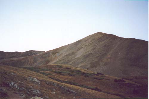
Huron Peak Elevation 14,012ft. (Aug. 25, 2002) "South Clear Creek Trail Head", this trail is a class 2, trail runs (4.0 miles rt. with 3,400ft. gain). This TH also know as the South Winfield 4X4 TH, is located 2 miles down a 4X4 road starting at the small town of Winfield. The first .5 miles of the 4X4 road is very rough, but after that point the road flattens out and in not too bad. The Huron Peak trail starts at the Forest Service closer gate. The trail up to the summit was very well maintained, except the last 300ft. The trail uses many switchbacks and crosses a beautiful basin.
The night before the climb I had the pleasure of watching a community of Snowshoe Hare play and eat just after sundown. They were curious enough to get close to my truck and then jump back and run around. In the morning on the hike up I ran into some more Snowshoe Hare as well as some Mule Deer in the high mountain basin. After climbing up the first thousand feet through the trees, the trail emerges above tree line and into a high mount basin. The trail continues across the basin to the other side where it turn to the right and switchbacks up the Huron's North slope. Once you reach the north ridge, at the top of the north slope, the trail reaches to top by going straight up to the top. The trail from the ridge to the top was in poor condition. The views from the top of Huron Peak where unbelievable (many books have mentioned the views from the top of Huron being the best in the Sawatch range). I would have enjoyed the views a little longer, but my body was pleading for relief, so I headed back down the mountain to give my body some well deserved rest.
Trip Schedule break down
| Sunday | 5:30AM | -leave South Clear Creek TH to climb Huron Peak. (previous day Belford Group). |
| 7:52AM | -summit Huron Peak. | |
| 8:10AM | -leave summit and head down. | |
| 9.55AM | -back at the TH. | |
| 2:00PM | -back home. |