James Peak - Rollinsville Day Trip
- Indian Peaks Range
Summary
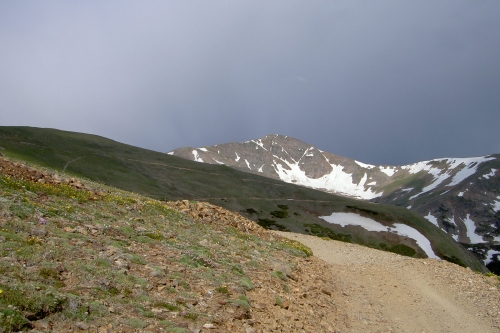
James Peak Elevation 13,294ft. (July 3, 2005) "East Slopes" trail from Kingston Peak(FDR353) road. From this TH, this class 1 trail runs (7.5miles rt. with 2,362ft. gain). There are several trailheads, the most renowned one is at St. Mary's Glacier. Our trailhead is found by taking either FS road 4N from Tolland and then taking FDR353, or coming from Apex on FDR 353. This is also the way to get to James Peak Lake trailhead.
The road to the TH was not that difficult, however we were stopped by a large snow drift. Some vehicles managed to get through the drift, but on the way back through in the afternoon when the snow was softer, they had a little more trouble. The last part of the road that we ended up walking was pretty steep, so even a high clearance vehicle would have problems. With the steep incline it would be best to have a 4X4 with lower gears to make it all the way up to the James Peak Lake TH.
Read More Details or View Slideshow
Trip Schedule break down
| Sunday | 8:41AM | -leave Car at snow drift (10,932ft.) |
| 12:00PM | -Summit James Peak. | |
| 2:15PM | -back at Car |
From the James Peak Lake TH you can go down to the lakes and then around and up to James Peak's North ridge. Once on the ridge you can then make your way back to the Summit. One the other you can avoid the steep class 2 climb up to the ridgeline on the North ridge route and go for the easy East Slopes. The East slopes route takes the road south of the TH and up into the valley above St. Mary's Glacier. From here you can either stay close to the ridgeline and climb up or go further into the basin and the center of the large East slopes.
We ran in to a some snow fields on the way up so we decided to stick to the ridgeline and avoid the snow for the way up. On the way down we used the snow fields in the center of the East slopes to slide down to the bottom.