Longs Peak - Estes Park Trip
- Front Range
Summary
Longs Peak Elevation 14,261ft. (Aug 16, 2003) "Keyhole" trail from Longs Peak Ranger Station TH. From this TH, this class 3 slopes II trail runs (15.0 miles rt. with 5,000ft. gain). TH directions are as follows, take I-70 West to Central City/Blackhawk exit, then use 119, 72, and 7 to get to Longs Peak Ranger Station. The biggest issue with climbing Longs Peak is the crowds. I was suppose to be in NYC this weekend, however a turn of events set me up for a moonlit hike up Longs Peak. With the moon out this weekend the normally crazy peak baggers were joined by many other groups of crazies. The trail was long but not particularly difficult. The distance and climbing is comparable to La Plata and the last couple of moves where not more difficult then Wetterhorn.
Read More Details or View Slideshow
Trip Schedule break down
| Friday | 7:00PM | -left Tim's Place (I-70, Blackhawk, Nederland) |
| 10:30PM | -arrive at Longs Peak TH. Find another place to spend the night. | |
| Saturday | 2:25AM | -leave the TH to climb the Longs Peak. (after driving back to the TH) |
| 6:35AM | -summit Longs Peak via KeyHole | |
| 11:15AM | -back at the TH. | |
| 2:00PM | -Gambling in Blackhawk. |
My original plans were to be in NYC this weekend with my girl friend, however the Eastern Power Grid had other plans. LaGuardia international airport was only excepting international flights in and out. So with this turn of events I made a call to my climbing buddy (Tim) and headed to Estes Park for a Moonlit Climb of Longs Peak. I have been wanting to get longs peak out of the way because all I hear from people when I say I climb peaks is, "Have you climbed Longs Peak." I would have to say that it turns out that the only people who climb Longs peak are those needing to get all 54 peaks, or those who have never climbed any other peaks. What this means is when you read a trip/summit report of Longs peak you need to take it with a grain of salt and with this question in mind, "What background is the writer coming from?" In my case this is my 47th peak.
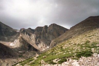
The easiest route on Longs Peak, the "Keyhole". The round trip distance for this route is 15 miles and therefore longer then most other single day fourteener routes. The trail includes some class 2 boulder scrambling to the keyhole and a class 2 ledge walk around the backside. The route up the couloir in back is no more difficult then the scramble to the ridgeline on Mount Sneffels. The final move out of the couloir is a class three move and the narrows is a rather sallow (not that steep) class three climb. I would compare the keyhole route to the climb up La Plata, however the distance issue encourages the climber to be in better shape.
As all 14ers in the Front Range you find many inexperienced hikers, and the people watching is great. Here are a couple fun observations of hikers behaving badly:
| Hikers in sandals and tennis shoes. | |
| Hikers not carrying any water. | |
| Hikers carrying plastic bags of gear instead of a backpack. | |
| Hikers sleeping on the asphalt in the TH parking lot next to "No camping in parking lot," signs. | |
| Hikers carrying water in a plastic bottle for a class three climb. (hmm... what does class 3 mean again?) | |
| Hikers leaving the TH after 8:00AM for an average 12hr hike. | |
| Hikers taking pictures in the dark. (I hope they like ink blot pictures) | |
| Hikers sitting and taking up every square inch of the keyhole. (hmm... I am trying to hike here, can a few of you move?) | |
| Hikers selling peanuts, popcorn, cracker jacks, red liquorish, cotton candy, and circus peanuts. (ok, maybe I am exaggerating a little here) | |
| Hikers taking there pets on the trail when it is posted, "No Pets." Opps, I am part of that story. |