Mount Sherman - South Park Trip
- Tenmile Range
- 2002 Report
Summary
Mount Sherman Elevation 14,040ft. (Jun. 26, 2004) "Dauntless Mine Trail Head", this trail is a class 1, trail runs (3.5 miles rt. with 1,800ft. gain). Depending on how far you wish to travel on the fourteener, or how much you can or are able to four-wheel-drive, depends on where you start your climb. In 2002 I was able to actually drive further up the four-wheel-drive road, however on this date the road was blocked by a steel gate. On this climb I was joined by Courtney, my fiance, she had never climbed a fourteener so I suggested that we start off with Sherman.
Read More Details or View Slideshow
Trip Schedule break down
| Saturday | 4:30AM | -left the house. |
| 6:40AM | -leave the TH. private property gate. | |
| 9:00AM | -summit Mount Sherman. | |
| -rest for 10 minutes on the summit. | ||
| 10:40AM | -back at the TH. | |
| 11:40AM | -Lunch at the Kenosha Pass Picnic Area. | |
| 1:30PM | -back at home. |
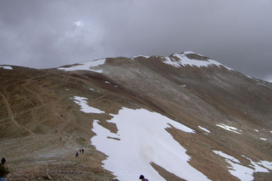
On this date I actually took a different route up Sherman, we went up the jeep road and by all the mines. On the previous trip, I went straight up the valley/gully between Sheridan and Sherman and then turn right at the end of the valley and up some steep switchbacks to the saddle. On this occasion, I opted for a longer but much easier and scenic climb up the jeep road. By following the jeep trail and a number of cairns the trail to the Saddle was no problem. We had to cross two small snow fields about 100 yards before reaching the saddle, but the snow was in very good condition. Above the saddle we encountered some ice covering the lose scree and rocks, but I have seen worst. By the time we were on our way back the ice was really breaking up due to the temperature and the number of people that were now on the trail.
The infamous windy ridgeline did not let us down today. We bundled up before reaching the narrow part of the ridgeline so that we would not catch frostbite. The temperature was cold and we where glad to have our snowboarding gloves with us. There are numerous trails on either side of the ridgeline so the route we took up was actually different then the one we took down. As we approached the summit the clouds continued to block our views. I remembered from my previous summit that the ridgeline flattens out, but the summit is still a fair walk away. Even with the large cornice of snow on the east side of the ridgeline, the rock wind block containing the plastic tube and summit registry could still be found.
The hike down was uneventful, and that is the way a like it. We reached the summit as number two and three for the day, but from the look of the traffic coming up the trail while we were going down, many others were going to summit this day. As par for fourteeners, I saw a couple people heading up to the summit when we were almost back to our truck, I hope they have rain coat and an affinity for resisting electrical current/charges.
Final note, we did not need or bring a snow axe, but you could probably have some fun on the snowfields if you brought one.