Mount Sneffels - Ouray Trip 2003
- San Juan Range
- 2004 Report
Summary
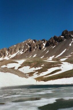
Mount Sneffels Elevation 14,155ft. (June 22, 2003) "South Slopes" trail from Yankee Boy Basin (4X4) trailhead. The South Slopes trail up Mount Sneffels is a class 1 to 2+ trail that runs (4.5 miles rt. with 3,000ft. gain). From wherever you decide to start your climb, you go up a jeep trail and then onto a hikers trail. The slope is easy until you reach the talus field at the base of Sneffels. From the talus field to the summit, the trail is steep and contains loose rock. I personally enjoyed climbing up a couple of the remaining snow fields that were still present on the steep slopes of Sneffles. The gully to the summit was filled with snow as well and I was lucky that hikers the previous day cut some nice foot holds in the frozen slope that I was greeted with at 7:30AM in the morning.
Read More Details or View Slideshow (the slideshow is a mixture of trips)
Trip Schedule break down
| Saturday | 3:30PM | -Arrive in Ouray. Earlier in the day I climbed San Luis Peak. |
| Sunday | 5:30AM | -leave campsite and a drive to TH. |
| 6:00AM | -leave TH to climb the Mount Sneffels. | |
| 8:00AM | -summit Mount Snefflels via South Slopes | |
| 9:40AM | -back at the TH. | |
| 4:30PM | -back at Home. |
The first part of the trip starts before you ever get out of your vehicle. The issue is where is the suggested parking lot that makes the climb a legitimate 3,000ft. gain climb. Roach's book and the current maps of the jeep trails do not agree on any information. Also the 4X4 road goes across private property so camping any where close to the TH is not possible. I decided to spend the night at a campsite off of the Imogene Basin jeep trail, and then drive to the TH in the morning.
After figuring out the parking situation, I hiked up to the registry box, signed in, and was off on my way to Sneffels. There are numerous trails in the upper part of Yankee Boy Basin, and the fastest way to the mountain is to just stay on the jeep trail instead of following the trail next to the registry. Either way you end up at the base of Sneffels, make sure you are not fooled by the peaks. You can not see Sneffels until you get up into the basin and the mountain is on your right...not the peak right in front of you at the registry box.
From the base of Sneffels to the top I hiked the snow fields on the left side of the scree field and made my way to the ridge. Make sure you go to the ridge and not the couloir that is further down from the ridgeline. From the ridgeline up the chute, the climb is probably loose scree, but this early in the Spring the couloir was filled with snow. The only thing tricky here is that you have to take the crack that goes to the left about 20 feet from the top of the chute. The chute goes right off the front of the mountain and then several thousand feet down. The couloir is visible from the road from Montrose to Ouray.
The following are the best parts of the trip:
| 1.) | The views on top of Sneffels, which included a great view of Uncompahgre and Wetterhorn. |
| 2.) | The awesome jeep trail into Yankee Boy Basin. |
| 3.) | The deer that got within 20 feet of my truck late Saturday night. |
| 4.) | Making use to the snow fields going both up and down Mount Sneffels. |