Pikes Peak - Divide Day Trip 2004
- Front Range
- 2003 Report
Summary
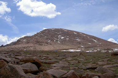
Pikes Peak Elevation 14,115ft. (Jun. 12, 2004) "Crags" trail from Crags Campground TH. From this TH, this class 2 trail runs (11.5 miles rt. with 4,100ft. gain). TH directions are as follows, take I-25 South to Colorado Springs and the Woodland Park Exit 141, go 18.4 miles on C24 Northwest to the C67 and C24 junction, go West on C67 to Divide another 6.8 mile, stay on C67 at Divide which turns to the South, next go 4.3 mile to a Rocky Mountain Camp sign and turn left on Teller Co 62, go up to Rocky Mountain Mennonite Camp and then stay right to the Crags Campground. The hiking trail out of the Crags is nice, however once you get to Pike Peak road, the trail along the side of the road is not that interesting. This was my second time up Pikes Peak from the Crags, and this time I have a couple friends.
Read More Details or View Slideshow
Trip Schedule break down
| Saturday | 4:00AM | -left the house. |
| 4:20AM | -Met up with some friends to drive to the TH. | |
| 6:20AM | -left the TH at the Crags Campground. | |
| 9:45AM | -summit Pikes Peak, had some donuts and coffee. | |
| 10:00AM | -left the summit. | |
| 1:05PM | -back at TH | |
| 3:05AM | -back home. |
The Crags is a beautiful area, and the trail has had some major improvements over the past couple of Summers. The key to getting on the right trail use to be seeing the three pipes on the left side of the trail and then go to the right about 30 feet after them. The new key is just noticing that a well marked trail branches to the right, and is with ###A. There is also sign not too far up the trail indicating that the trail goes to Devils Playground. Because I was traveling with friends this time up Pikes Peak, I was moving at the pace of the group. The parking lot at Devil's Playground continues to be one big erosion area. The trail from the parking lot to the summit follows next to the road, but ended up going around one big rock pile. The trail at times is closer then the 50ft. minimum to the road, but one one stopped to give us any hassle. I found that the last boulder step section was easier to find and the cairns more visible. Some of the trail still tends to be a tangle of cairns and worn paths, but your destination is always within view.
If you want to see some of my comment about the summit see the 2003 report, but needless to say climbing a peak with a tourist shop on top has limit reward. However this time with friends, donuts, and coffee I managed to enjoy myself.
Note: The parking lot at the Crags Campground tends to fill up fast on the weekends. Also, a 4 dollar day use parking fee is required at the TH parking lot.