San Luis Peak - Creede Colorado Trip
- San Juan Range
Summary
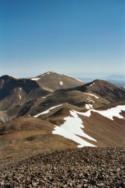
San Luis Peak Elevation 14,019ft. (June 21, 2003) "East Slopes" trail from Stewart Creek Trailhead. The Stewart Creek trail up San Luis Peak is a class 1 trail that runs (12.0 miles rt. with 3,600ft. gain). Getting to the trailhead is the hardest part of the this climb. It took a little over 4 hours to get to Gunnison and then from there it took 2 hours to go 60 miles down some dirt roads. I was the first person to get to the trailhead, so I got the prime camp spot. The climb was a steady slope up a valley and then to the left and up to a saddle. Once you get to the saddle you can finally see the summit back to your right.
Read More Details or View Slideshow
Trip Schedule break down
| Friday | 11:00AM | -left work (went via Buena Vista, Salida, Gunnison, back to US114) |
| 5:00PM | -arrive at Stewart Creek Trailhead | |
| Saturday | 5:30AM | -leave the TH to climb the San Luis Peak. |
| 8:30AM | -summit San Luis Peak via East Slopes | |
| 11:10AM | -back at the TH. | |
| 12:00PM | -leave Stewart Creek Trailhead and drive to Ouray. |
There was one other person that left the TH in the morning before I did. I caught up to him when the trail got above tree line. At this point I was excited to see all the wildlife grazing in the high mountain basin. There were a couple herds of elk and some deer. The hike up the valley passed beaver pond after beaver pond. I was impressed with some of the construction work that the beavers had done.
For some odd reason a particular cairn was littered with water bottles as well as a Gatorade bottle. I am not sure what the reason is here, but this particular cairn that is on the trail up to the saddle between San Luis Peak and Organ Mountain was somehow acting as a bartender for fine bottle water and sports drinks.
The hike from the saddle to the summit follows a trail over scree much like the slopes of Grays and Torreys. Like all of the early climbs that I have done this Spring, the summit was very cold because of the wind. On the way back to the truck however the sun had really started to warm things up and I was in a T-shirt by the time I made it back to the truck. On the way back I passed a couple of women who had attempted to climb the peak but turned back because one of them was not feeling so well. Back at the TH I packed and stowed my gear and was off quickly to Ouray.