Snowmass Mountain - Snowmass Trip
- Elk Range
Summary
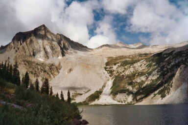
Snowmass Mountain Elevation 14,096ft. (Sept. 6, 2003) "East Slopes", trail from Maroon-Snowmass TH and Snowmass Lake Campsite. From this TH, this class 3 trail runs (21.0 miles rt. with 5,700ft. gain). The backpack in from the TH is not overly difficult, but it is long and just when you think that you must be getting close to the "Log Jam" area, you still have away to go. There is a nice kind of rock-bleacher setup to look up Bear Creek at Snowmass Mountain, from this point you continue up into a saddle as you approach the "Log Jam" area. The climb up to the Summit of Snowmass involves bush-whacking around the lake, carefully going up some loose dirt and scree, across a large boulder field, and finally up some loose talus to a class three ridgeline climb up to the summit.
Read More Details or View Slideshow
Trip Schedule break down
| Friday | 12:00PM | -left work (drive to just within 13 miles NW of Aspen on 82) |
| 3:35PM | -arrive at Maroon-Snowmass Trail Head. | |
| 4:00PM | -leave Maroon-Snowmass Trail Head headed for Capitol Lake. | |
| 7:30PM | -arrive at Snowmass Lake campsite. | |
| Saturday | 6:15AM | -leave the campsite. |
| 8:30AM | -summit. | |
| 10:45AM | -back at campsite. | |
| 12:00PM | -leave campsite headed for the the truck. | |
| 3:15PM | -back at parking lot TH (15min. rain delay) |
Before I even got to the trailhead, I was already getting poured on. I managed to get my rain gear on while in the truck and then headed off down the trail. I couldn't waste anytime waiting for the rain to let up because I knew that if I did I would be hiking in the dark before I made it to the lake. From the trailhead you go through three gates before you get into the wilderness area. The trail is in pretty good condition and this time to Aspen I didn't have to contend with cows (a reference to the Capitol Creek trail). During the first part of the hike you pass through a valley that has really large boulders scattered throughout it. The dense aspen trees and large boulders make for a cool late summer scene. Also along the way you may notice the beautiful wildflowers, this hike is among the favorites for wildflower aficionados. After the "Log Jam" area the trail does a steep switchback up the side of the valley and up to Snowmass Lake. Once you get to the lake you will notice the large rocks embedded into the creek bottom near the lake to creek exchange. The creek flows as a thin layer over the rock and down into the creek bed. It is amazing to think how different Snowmass Lake would be without this rock, maybe there wouldn't even be a lake. The power of this rock to hold back the entire like is incredible.
I arrived at the lake sweaty, hungry, cool, and almost in complete darkness. I managed to get the tent put up with a little bit of light to help, but I ended up doing a water run and cooking in the dark. During my last run to the water to fill up my pack for the climb the next morning, I saw the clouds and then snow come down from Snowmass Mountain and Peak and glide over the lake towards me. I managed to keep my hands warm enough to finish up purify water for my camelback bladder and make if back to the tent. Once back at my tent I bundled up, shook my head in wonderment, and listened to the snow lighting fall on my tent. The ice crystals fell for about 20 minutes and then let up.
In the morning I was delighted to find great visibility up to about 15,000ft where the cloud ceiling was. I met up with three guys on my way around the lake, what do you know, two of the guys I recognized from my Durango trip. One, of the guys was Mr. Flatulence, who was on his final 14ner climb, number 54. He had climbed Culebra two weeks earlier and told me about the bad weather he had that day. I passed this grouped and really put some distance between then and me while on the scree climb to the upper basin. I took the left ridge of the scree ravine, and was careful not to knock any rocks down below. The ground was a little damp from the precip the night before and this was helpful at keeping the rock, scree, and dirt combination from moving.
Once in the upper basin, cairns go in every direction and it seems like a free-for-all to the ridge of Snowmass, which is in the far corner of the basin. I tried to stay on the large slabs of rock as mush as possible. If you can keep you boots dry, clean, and off the sand then the rock provides good traction. From what I heard from some other hikers was that they had never seen the Snowmass basin as void of snow as it was this September. I an not sure whether the lack of snow made it better or worse for climbing. Once you get near the ridgeline you encounter more loose sand and talus. The best way may be to stay further to the left or Southeast before gaining the ridgeline, but with some careful foot work I went straight up and over the ridgeline and to the back side which contains the easiest trail to the summit.
The summit is among the smaller summits that I have been on. The view to Capitol was obstructed by clouds, but the valley under Capitols summit was in clear view. The temperature was cold, so I made a quick turn around and made my way back down into the upper basin. I passed the other group of three climbers as the were beginning there class 3 climb up the ridgeline to the summit. As I passed, they mentioned that hey were going to spend some time on the summit and open a bottle of campaign for the one guy who was completing his 54th. The way back was uneventful and had me stripped down to my shorts and T-shirt by the time I made it back to camp. The scree ravine going down had loosed up, as it began to dry out, so I took my time and was glad that no one was below me.
The backpack out went well, except for a down pour which lasted about 45 minutes, I can not complain as it was the afternoon when you expect rain. The most disconcerting thing was that I past a family of three hikers at 1:00pm, about 2 hours from the lake, that thought that they were going to be able to climb Snowmass that day. The most wonderful encounter was that of an older couple that were out just to get some exercise and enjoy the fall, it was this couple that made me think of what I would still like to be doing when I am that age.