Uncompahgre Peak - Lake City Trip 2004
- San Juan Range
- 2002 Report
Summary
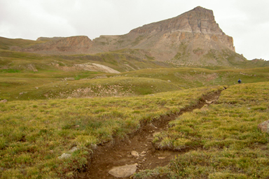
Uncompahgre Peak Elevation 14,314ft. (Aug. 21, 2004) "Nellie Creek TH: Uncompahgre's East Slopes", this trail is a class 1 and 2, that runs (7.6 miles rt. with 2,870ft. gain). Nellie Creek Road takes a good 4-wheel drive vehicle, and one with a good turning radius helps. The TH parking lot is quite large, so parking is not a problem. The climbing trail is well worn and you travel across soft earth instead of piled rocks. The trail switchbacks up the grassy East slopes of Uncompahge and then cuts around to the West side of the peak in order to gain access to the upper plateau that makes up the summit. Uncompahgre Peak and the trail to get to the summit is visible within the first 20 minutes of hiking. There are two main intersections on the trail, the first happens at about 1.3.mile. At this intersection stay on the Nellie Creek Trail (left) and keep your heading towards the peak. At the second, which is on the grassy shoulder of the East slopes trail, you encounter the Southwest Slopes Trail coming from Matterhorn TH. At this intersection stay to the right and climb up the ridgeline to the summit.
Read More Details, View Slideshow, or See the wallpaper
Trip Schedule break down
| Friday | 12:00PM | -leave work (US-285 to Salida, US-50 West to Gunnison, and South to Lake City) |
| 5:30PM | -arrive at Nellie Creek TH. | |
| Saturday | 6:45AM | -leave Nellie Creek TH. |
| 9:20AM | -summit Uncompahgre Peak | |
| 11:05AM | -back at Nellie Creek TH. | |
| 1:00PM | -leave Nellie Creek TH, bound for Ouray vie Engineer's Pass | |
| 4:20PM | -arrive in Ouray. | |
| 6:00PM | -arrive at Yankee Boy Basin campsite near Mount Sneffles TH. | |
| Sunday | 8:00AM | -wake up and have Breakfast. |
| 11:30AM | -drive back to Denver via Grand Junction and I-70. | |
| 6:30PM | -back in Denver. |
The drive to Ouray was nice and we arrived at our campsite in good time. The 4x4 trail up to our campsite was the first of many test of the new 4Runner. Saturday morning we climbed up Uncompahgre and had to deal with some corn snow. The views we had on the trip were a mixture of good and bad. On approach to the summit we have views but on top we were in the clouds.
Back at our campsite we packed up and headed to engineer's pass. I had been up to Engineer's Pass 2 years previous with my Chevy pickup, no problem On the pervious trip I had used the Cinnamon Pass to Engineers pass route to travel between the Handies and Uncompahgre groups. So not this trip I had no problem going overt the pass and down to the intersection on the Ouray side of Engineers Pass. From this point on was all new territory. I should had done a little more research on this section because we ended up spending 2 hours traveling the next 8 miles to Ouray. The road was much more difficult then I would have liked. It was fun in retrospect, but a white-knuckle ride during the endeavor. (I recommend that you rent a jeep for this one, if you want to do it at all) I would have been in serious peril with my old truck; I think that I would have had to go back instead of being able to go forward. Having never been on the section of scenic byway that goes from Engineer's Pass to Ouray I didn't know if the road/trail was going to easier of more difficult. There was a small stock Chevy Blazer behind me, and I felt sorry for them because I am not sure that they made it through without any body damage.
Once in Ouray we checked out the town for a shorter amount of time then we would have liked, seeing that we spent an extra 1.5hrs on the dirt road then we had expected. Up into Yankee Boy basin is another 4x4 road, but one I have been on a number of times. We made it to camp and started to prepare supper when we got interrupted and ended up helping someone get their pickup back onto a road. The rest of the evening was nice with a fire an smores.
We were just preparing for bed when the rain started and lasted for the next two hours. We stayed dry in the tent and fell asleep to the sound of rain drops on the tent.
Morning came and we had a much less eventful breakfast. As many other camper got up early and climbed Mount Sneffels, we slept in an enjoyed the Sun with our morning meal instead of the blue glow of our head lamps. The drive back to Denver was fine, however long and involving the I-70 Sunday afternoon parking lot from Silver Plume to Idaho Springs.