Wilson Peak - Telluride Trip 2004
- San Juan Range
- 2003 Report
Summary
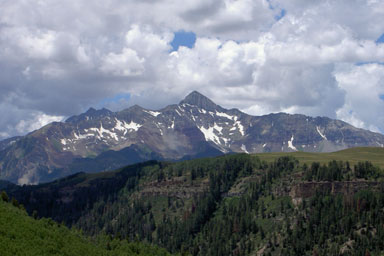
Wilson Peak Elevation 14,024ft. (July 18, 2004) From Silver Pick TH I traveled up to the saddle right above the "Rock of Ages" mine and around the ridgeline between Wilson Peak and Gladstone Peak The trail is a class 2 with some class 3 just below the summit. The climb statistics are (7.0 miles rt. with 3,350ft. gain). My previous trip in 2003 included a climb of all Wilson group peaks in one day.
Read More Details or View Slideshow (the slideshow is a mixture of trips)
Trip Schedule break down
| Friday | 4:00PM | -left Tim's place (Drive to Telluride via I-70 to Grand Junction, then 50 to Ridgeway) |
| 10:30PM | -arrive at Silver Pick TH | |
| Saturday | 4:45AM | -leave the TH to climb to the "Rock of Ages" saddle/pass and then on to Wilson Peak. |
| 7:53AM | -summit Wilson Peak via "North Ridge". | |
| 11:07AM | -back at TH | |
| 2:30PM | -in Ouray. Next day climb of Mount Sneffels. |
We (Tim, Hilda, and I) arrived at the TH after many camper/hikers had already gone to bed. We did not have any trouble with mosquitoes or biting flies...yet. I remembered the route to the TH, and therefore we didn't have any problems finding it. However for those trying to find it for the first time, when the Roach book says to take the middle of three choices at an intersection, you should pick the road that goes straight but slightly to the right. The far right choice makes a U-turn or switchback to the right, and the left choice is the most traveled road of the three.
In the morning we woke up and hit the trail. I had somehow blocked out the painful 4X4 road to the upper saddle from my memories of last years trip. It did not take me look to pull those memories back up, however. There was less snow on this trip and route finding was easier. We did however manage to use a number of snowfields to get to the "Rock of Ages" saddle. The long traverse to the saddle along the western slopes remain loose and at times difficult to travel.
Once at the saddle, the sun was just coming up and started to bathing Mount Wilson and El Diente with sunlight. From the saddle the trail traverses over to the ridgeline between Wilson Peak and Gladstone Peak. Continuing from the ridgeline the trail traverses up the backside of Wilson peak on some loose talus, however good route finding should avoid any major difficulties. I should say this lightly, having traveled this traverse now four times I am not sure that I have successful made it through without getting of trail and having to make some more difficult moves on loose rock. The long traverse eventually meets up with ridgeline where you drop over onto the front side and climb up and over one rock formation and down into the finally gully up to the summit. The most technical part of the climb it not the finally climb, but however the short 30ft. drop down to the final gully. The rock on the final gully is pretty solid and should provide little difficult if you take care to test each hand hold before weighting it. Form a comparison stand point the final section is much like Wetterhorn, but the rock on Wetterhorn is even better in quality.
We made it back to the TH to find that the mosquitoes from the previous evening that were sleeping where up and ready to feast. We quickly sprayed down with repellent and went to work packing up. My last comment is that the Silver Pick Basin TH may end up being closed to hikes in the next year or two due to legal battles between private land owners and the forest service.